I am sure when you visit a new city or a try to look for directions before visiting an unfamiliar place, you look up Google Maps. Now there is a new added layer on Google Maps which will allow people to see how the weather is in a particular place.
If you are looking at cities on a map, all you have to do is hover the mouse over to the top right hand corner of the map and we see a new ‘weather’ option added.
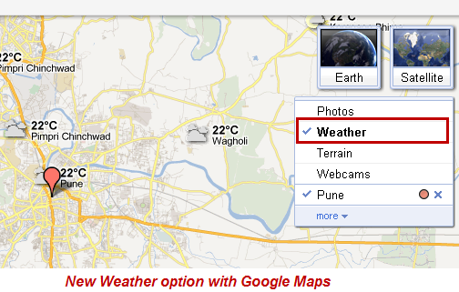
Clicking on it adds a weather layer on the maps showing users the temperatures and weather conditions.
Another feature is if you zoom into a city, Google Maps also shows a 5 day weather forecast of that city on the left hand panel.
Here is a video that explains the workings of Google Maps Weather feature.
How Google manages to show ‘weather’ results?
Google is collaborating with weather.com, a website which shows weather forecasts. The new layer on Google Maps takes data from this website for its weather predictions.
I guess this new addition on Google Maps makes sense, considering so many people plan their trips with Google Maps. What are your views? Do drop in your comments.
3 Comments
yes its really nice feature integrating with Weather. Also for your all information Google maps have integrated the local Transport details in New Zealand. So you can even check how to go from one destination to other destination by taking public transports. It give you the details of which bus you have to take and what time is the bus and what time u will reach your destination and etc.
If you look closely you’ll also see the sun and moon icons which tell you if it’s day or night in a particular city. For those of us who don’t know, early this year google introduced a fuel calculator in it’s maps for Europe which can help you calculate the fuel cost of a particular trip.
Thanks, I had not noticed the day and night feature. Thanks for letting me know.